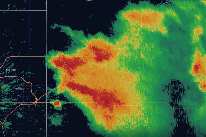
In short: a hook echo is a curl of rain and hail wrapped around a thunderstorm’s rotating updraft. It tells you the storm is rotating. It does not tell you a tornado is on the ground. Forecasters weigh it together with two other radar signatures, a tight velocity couplet and a dual-pol debris signature. Only the debris signature comes close to confirming a tornado, and only after it has started. This guide shows what each one looks like and what it does and does not prove.
Safety first, because it matters: never wait to see a signature before acting on a tornado warning. Warnings draw on spotter reports, the storm’s environment and data you do not have. Radar literacy is for understanding and anticipation, and the National Weather Service always gets the last word.
What a hook echo looks like on radar
Look at the opening image. The storm is moving toward the northeast, and on its rear flank, the southwest side, a thin arm of echo curls down and back toward Andover. That arm is the hook. The pocket of weak echo it wraps around is the rotating updraft, where air is rising too fast for rain to fall through it. The tip of the arm is where the tornado was.
What to look for, in order:
- Where: the rear flank of a strong, isolated storm, on the right-hand side relative to its motion. For the usual northeast-moving storm in the United States, that is the southwest side. Hooks form on the right-rear flank because that is where the rotating updraft sits and where the storm draws its inflow.
- Shape: a comma tail, a pendant, or a fish hook, often a few miles across and much smaller than the storm it hangs from. Some are a crisp curl; many are a stubby appendage or just a notch cut into the flank.
- Which product: base reflectivity on the lowest tilt. The hook lives in the lowest mile or two of the storm, so composite reflectivity, which takes the strongest echo from any height, often smears it out. Super-resolution or Level 2 data keeps a small hook sharp further from the radar. (In MesoRadar: the Local tab, Reflectivity, Super-Res or Level 2, tilt 0.5°. Where to find it.)
- The tip: if the tip of the hook thickens into a blob of high reflectivity, that may be debris. Forecasters call it a debris ball, and it belongs with the debris signature below.
The hook has been the public’s picture of a tornado on radar since April 9, 1953, when a radar technician at the Illinois State Water Survey, testing a research radar at Willard Airport south of Champaign, filmed a hook-shaped echo from a storm that was producing a tornado north of the city. It is also the most over-read shape on the map, which is why the rest of this guide exists.
Supercell anatomy in one diagram
A supercell is a thunderstorm with a persistent rotating updraft, the mesocyclone. That rotation organizes the whole storm into a repeatable structure that radar sees clearly.
- 1Forward-flank core. The main rain and hail shield, downwind of the updraft.
- 2Mesocyclone. The rotating updraft. Weak echo here on low tilts: air is rising too fast for rain to fall through it.
- 3Hook echo. Precipitation dragged around the rotation by the rear-flank downdraft.
- 4Typical tornado position. The tip of the hook, where the downdraft meets the inflow.
- 5Inflow. Warm, moist air feeding the storm through the echo-free notch.
- 6Storm motion. Northern Hemisphere; mirror the picture south of the equator.
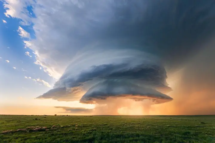
The pieces to know:
- Forward-flank core: the storm’s main precipitation and hail shield, downwind of the updraft.
- Updraft / mesocyclone: the rotating engine. On low-level reflectivity it is often a weak-echo region, because air is rising too fast for precipitation to fall through it. On mid-level tilts a pronounced version appears as the BWER.
- Rear-flank downdraft (RFD): descending air wrapping around the back of the mesocyclone. This is what sculpts the hook: the RFD drags a curtain of precipitation around the rotation, drawing its outline on radar. Worth knowing, because the old shorthand has it backwards: field measurements show the RFDs of tornadic supercells tend to be only slightly cooler than the inflow air, while a cold, heavily rain-chilled one usually chokes the circulation off (Markowski, Straka and Rasmussen 2002).
- Inflow notch: the clean, echo-free wedge where warm moist air feeds in. A crisp notch means a healthy, breathing storm.
So a hook echo is not the tornado. It is precipitation tracing the rotation, the mesocyclone made visible.
What the hook leaves out
It fails in both directions:
- Hooks without tornadoes. Plenty of supercells cycle through beautiful hooks and never put a tornado down. A mesocyclone is a precondition and nothing more; most mesocyclones never produce a tornado.
- Tornadoes without visible hooks. High-precipitation (HP) supercells bury the hook in rain. Distant storms lose the hook to beam spreading. And QLCS tornadoes (spin-ups along squall lines) often show barely any reflectivity signature at all, just a subtle kink or bowing segment.
This is why forecasters stopped treating the hook as the signal decades ago. It is one item on a checklist.
Storm modes: HP, LP, and squall lines
The diagram above is a classic supercell, one of three supercell shapes and the friendliest of the three. The other two, plus the squall line, each rearrange which product is worth your attention.
- High precipitation (HP). The updraft is wrapped in the storm’s own rain, so the flank shows a bloated kidney or bean shape where the clean curl should be, and the hook blends into everything around it. The tell is the notch cut into the leading or right flank, with the circulation sitting at the back of that notch. HP storms are common in humid air east of the Plains, and a classic supercell can turn HP late in life. On an HP storm, reflectivity shape stops being reliable: velocity and the dual-pol products carry the read, because the tornado is inside the rain.
- Low precipitation (LP). Almost nothing on reflectivity, sometimes a thin comma of echo. An LP storm can still drop large hail, so tilt up and look for a core sitting aloft before you write it off.
- Squall lines. Stop hunting for structure and work velocity along the leading edge, frame by frame, looking for small tight couplets riding the bulges. These circulations form and produce within minutes, and they are shallow, so at any real distance the beam often rides over the top of them. The radar signature itself gives little notice: in squall lines the tight rotation signature tends to appear only about five minutes before the tornado (Trapp et al. 1999). Warning statistics follow from that. Brotzge et al. 2013 found tornado warnings for non-supercell storms caught fewer tornadoes (roughly half, against 80 to 90 percent for supercells) with shorter lead times (about 12 minutes on average, against 17). Treat the whole line as dangerous, including the long stretches where no couplet is visible.
Second signature: the velocity couplet
Reflectivity shows you the shape of the rain. Velocity shows you the wind inside it, and rotation has a specific look: a small patch of wind blowing toward the radar directly beside a small patch blowing away, at the same distance from the radar. On storm-relative velocity that is green touching red. The tighter and stronger the pair, and the more scans it holds together, the more it matters. The full read is in Doppler Velocity, Explained.
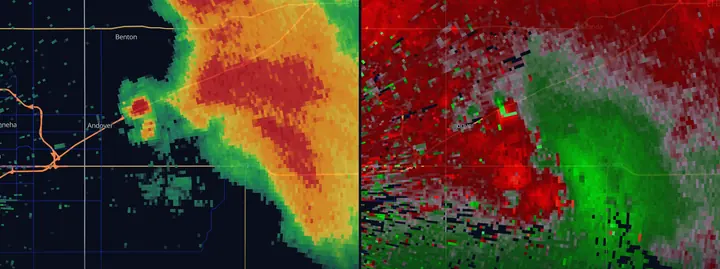
Third signature: the tornado debris signature
Since the dual-polarization upgrade finished in 2013, every NEXRAD radar also measures correlation coefficient (CC), a number that says how alike the targets in a pixel are. Rain and snow score close to 1.0. Lofted lumber, shingles, soil and vegetation are every shape and size at once, so CC collapses, usually below about 0.9 and often below 0.8. When that collapse sits right on top of a velocity couplet, inside real reflectivity (the NWS Albany method uses 35 dBZ or more), with differential reflectivity (ZDR) near zero, it is a tornadic debris signature, or TDS. It is the dual-pol clincher: a tornado is in progress and lofting debris.
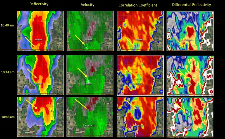
Four things to hold onto about the TDS:
- It confirms, it does not predict. Debris appears only after the tornado has started breaking things. Warnings are issued before that, on the couplet and the environment. The TDS is used to upgrade a warning’s wording to “confirmed” and to tell the public damage is already occurring.
- It needs reach. The debris has to be lofted up to the height of the beam, which rises with distance (see What Radar Can’t See). Weak tornadoes far from the radar, and tornadoes over open country with little to loft, often never show one. A missing TDS is never evidence against a tornado.
- Low CC has other causes. Very large hail drops CC too, and so do the bugs and birds pulled into a storm’s inflow. That is why the signature only counts when it sits on the couplet inside solid reflectivity.
- It lingers. Debris takes minutes to fall out, so a TDS can persist briefly after the tornado has lifted.
The dual-pol products and what they measure are covered in Dual-Pol Radar, Explained.
How forecasters weigh the three
Confidence stacks when independent products agree:
- Reflectivity structure: hook or appendage, inflow notch, tight low-level gradient on the storm’s right-rear flank. The storm looks like it is organizing. (How to Read Weather Radar)
- Velocity couplet: a tight, persistent, gate-to-gate rotation signature on storm-relative velocity, strengthening over successive scans, especially on the lowest tilts. This, together with the day’s environment and any reports, is what a tornado warning is usually issued on.
- Tornado debris signature: correlation coefficient collapsing on top of the couplet, inside real reflectivity. The nearest thing radar has to confirmation; spotter reports and damage surveys do the rest.
Two cautions. Forecasters do not wait for all three; a warning goes out on the second, and often on the first two plus a favorable environment. And a missing signature is never evidence against a tornado, for all the reasons above.
Reading the situation around the storm
A few habits that separate practiced readers from pattern-matchers:
- Watch the right-rear flank. In a typical Northern Hemisphere setup, discrete supercells favor rotation on their southern or southwestern flank. That is where hooks form and where new, tail-end storms get undisturbed inflow (“tail-end Charlie” is often the day’s most dangerous storm).
- Cycling is normal. Mesocyclones strengthen, occlude, and hand off to a new circulation, on a rhythm of tens of minutes to about an hour (Burgess, Wood and Brown 1982). A storm that just produced can produce again; a weakening couplet next to a newly tightening one is a handoff in progress.
- Range honesty. At 100 miles and beyond you cannot see low-level rotation: the beam is roughly 10,000 feet up and the pixels are more than a mile wide. Check the neighboring radar, or use MRMS rotation tracks to see accumulated low-level shear from the best available viewpoint.
- Squall lines have their own rules. They are covered in Squall Lines, Bow Echoes & Derechos.
Key points
- A hook echo is precipitation wrapped around the mesocyclone by the rear-flank downdraft: rotation made visible
- Plenty of hooks never produce, and plenty of tornadoes never show one
- The three signatures: reflectivity structure, a tight velocity couplet, and a debris signature on correlation coefficient
- Only the debris signature comes close to confirming a tornado, and only after damage has begun
- Storms cycle; tail-end and right-rear flanks deserve extra attention
- Act on warnings immediately; signatures are for understanding what a storm is doing
Common questions
What does a hook echo look like on radar?
A curl or appendage of rain and hail hanging off the back side of a strong, isolated thunderstorm, usually its southwest flank in the United States. On base reflectivity it looks like a comma tail, a pendant, or a fish hook, a few miles across, wrapped around a pocket of weak echo. The pocket is the rotating updraft. The tip of the hook is where a tornado, if there is one, usually sits.
Does a hook echo always mean a tornado?
No. A hook means the storm is rotating, which is a precondition for a tornado and nothing more. Many storms with textbook hooks never produce one, and many tornadoes, especially those in rain-wrapped storms and squall lines, never show a clean hook. Forecasters treat the hook as one clue and look for a velocity couplet and a debris signature before they say a tornado is confirmed.
What is a velocity couplet?
A small area of wind blowing toward the radar directly beside a small area blowing away from it, at the same distance from the radar. On storm-relative velocity it shows as green touching red. A tight, strong couplet that lasts for several scans is the radar signature of rotation, and the one forecasters weigh most heavily when issuing a tornado warning.
What is a tornado debris signature?
A pocket of very low correlation coefficient (a dual-polarization product) sitting on top of a velocity couplet, inside an area of real reflectivity. Lofted debris is every shape and size at once, so the radar's two polarizations stop agreeing. It is as close as radar gets to confirming a tornado, but it only appears once the tornado is doing damage, and only if the debris reaches the height of the beam.
Can radar confirm a tornado?
Not by itself. Even a debris signature appears only after the tornado has started damaging things, and distant or weak tornadoes may never produce one. A tornado warning is issued on rotation, environment and reports, before any confirmation. If you are in a warning, take shelter; do not wait for the radar to prove it.
Sources
- NWS Warning Decision Training Division, Radar & Applications Course (supercell structure, velocity signatures, dual-pol)
- NWS Sioux Falls, May 10, 2015 Delmont tornado event summary (debris signature image)
- NWS Wichita, April 29, 2022 Andover tornado event summary and damage survey
- Stout and Huff 1953, radar records Illinois tornadogenesis, the first hook echo on radar, April 9, 1953 (Bull. Amer. Meteor. Soc. 34)
- Markowski, Straka and Rasmussen 2002, surface observations in rear-flank downdrafts of tornadic and nontornadic supercells (Mon. Wea. Rev.)
- Ryzhkov, Schuur, Burgess and Zrnić 2005, polarimetric tornado detection (J. Appl. Meteor.)
- Brotzge, Nelson, Thompson and Smith 2013, tornado warning performance by storm mode (Wea. Forecasting)
- Trapp et al. 1999, descending and nondescending tornadic vortex signatures (Wea. Forecasting)
- Burgess, Wood and Brown 1982, Mesocyclone evolution statistics (Preprints, 12th Conf. Severe Local Storms, AMS, 422 to 424)
- French, Bluestein, PopStefanija, Baldi and Bluth 2013, reexamining the vertical development of tornadic vortex signatures in supercells (Mon. Wea. Rev.)