In short: dual-polarization radar sends pulses both horizontally and vertically and compares the two returns. Three products come out of it. ZDR says how flat the targets are (big raindrops are flat, hail and snow are not). Correlation coefficient (CC) says how alike they are (rain near 1.0, a mix lower, tornado debris far lower). KDP says how much liquid water the beam passed through. Together they tell hail from heavy rain, find the melting layer, and confirm a tornado by the debris it lofts.
Classic radar answers how much energy came back. Dual-polarization answers what it bounced off. Since the national upgrade finished in 2013, every WSR-88D transmits pulses in both horizontal and vertical orientation, and comparing the two returns reveals the size, shape, and diversity of whatever is in the air.
Three products carry almost all of the value: ZDR, CC, and KDP. Learn what each one measures physically and the interpretations follow naturally. The typical values below come from the NWS dual-pol training flipchart forecasters keep at the desk; think of them as ranges, not switches.
The core idea: shape
Falling hydrometeors take on different shapes:
- 1Large raindrop, flattened by drag. Wider than tall, so ZDR runs high: roughly +2 to +5 dB.
- 2Drizzle drop. Surface tension keeps it round. ZDR near zero.
- 3Hailstone, tumbling as it falls. Every orientation averages to round: ZDR near zero, with huge reflectivity.
- Large raindrops flatten into hamburger shapes as they fall, wider than they are tall.
- Small drops stay spherical: surface tension dominates.
- Hail tumbles, presenting random orientations that average out to spherical, no matter how large the stone.
What ZDR measures
What it measures: horizontal return minus vertical return, in dB.
How to read it:
- ZDR clearly positive (roughly +2 to +5 dB): big, flattened raindrops. Heavy convective rain. (Tropical rain, made of many smaller drops, runs lower.)
- ZDR near zero with modest reflectivity: drizzle, or dry snow (dry snow sits around 0 to 0.5 dB). Single ice crystals, before they clump into flakes, are flat and can read much higher, +2 to +4 dB, at low reflectivity. High ZDR with weak echo in cold air means crystals, not big drops.
- ZDR near zero with high reflectivity (55+ dBZ): the classic hail signature. Enormous returned energy from targets that read as spheres means stones, not drops. This combination is how you pick the hail core out of a storm. One wrinkle: small hail that is melting wears a coat of water and reads like heavy rain, so the signature is cleanest for large, dry stones.
- The ZDR arc: in supercells, a thin band of high ZDR along the forward-flank edge. It is size sorting: strong low-level shear strips small drops away and leaves only the big ones along the inflow edge (Kumjian and Ryzhkov 2008). A crisp ZDR arc says the low-level shear is strong. That is one ingredient tornadoes need, and plenty of storms with textbook arcs never produce.
- ZDR columns: a narrow tower of positive ZDR reaching well above the freezing level marks a strong updraft carrying raindrops up before they freeze. A tall or growing column often comes before a storm’s surge in reflectivity and hail, so it is worth watching on the tilts above the freezing level.

Correlation coefficient (ρHV), the argument-settler
What it measures: how closely the horizontal and vertical returns from one pixel track each other. When everything in that pixel is the same kind of thing, the two channels agree almost perfectly. Throw in a mix of shapes, sizes and materials and they stop agreeing.
How to read it (typical values from the NWS flipchart):
- About 0.95 to 1.00: one kind of thing. Pure rain (light rain sits above 0.97, heavy rain a touch lower), or dry snow.
- About 0.90 to 0.97: still weather, but mixed. Wet snow, rain with small hail, a few very large drops among small ones.
- A sag in a flat layer at a consistent altitude is melting: snow turning to rain, the melting layer, which shows up beautifully as a CC dip (the flipchart puts wet snow at about 0.88 to 0.985). This is how you find the rain/snow line aloft in winter.
- Lower inside a storm core means large hail mixed with rain: roughly 0.85 to 0.95, down to about 0.75 for very large hail.
- Below about 0.8 to 0.9, sitting on a velocity couplet, inside real reflectivity: the tornadic debris signature (TDS). The early research criteria were strict (Ryzhkov et al. 2005 looked for reflectivity above 45 dBZ, ZDR under 0.5 dB and CC under 0.8 on a hook echo); the method NWS Albany teaches today looks for CC under 0.90 co-located with a gate-to-gate couplet and reflectivity of 35 dBZ or more, with ZDR near zero as supporting evidence. Thresholds vary a little from office to office. Lofted lumber, shingles, soil and vegetation are as non-uniform as targets get. A TDS means a tornado is lofting debris, or has just finished doing so. It is the nearest thing radar has to confirmation, used to upgrade warning wording in real time.
- Very low CC away from storms flags non-meteorological targets: birds, bugs, chaff, smoke plumes. The flipchart puts precipitation at about 0.9 to 1.0, and NWS training treats values under about 0.8 as usually not precipitation, with large hail the exception. CC is the fastest way to dismiss biological clutter you learned about in What Radar Can’t See.
Two cautions on the TDS. Low CC alone is not enough: large hail drops it, and so do the bugs and birds drawn into a storm’s inflow, which is why the signature only counts on top of the couplet inside solid reflectivity. And debris has to reach beam height, so weak tornadoes far from the radar, or tornadoes over open country with little to loft, often never show one. A missing TDS is never evidence against a tornado.
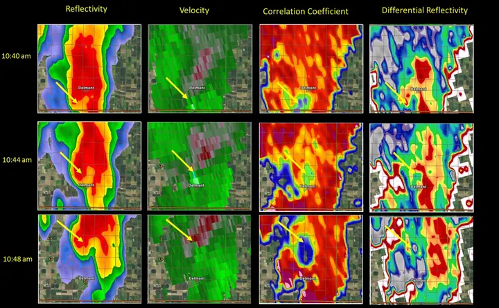

If you learn a single dual-pol product, learn CC. It is the one that tells you whether debris is in the air.
KDP and why hail can’t fool it
What it measures: how much the horizontal pulse gets slowed relative to the vertical as it passes through liquid water. Unlike reflectivity, it responds to liquid water content and mostly ignores hail (tumbling ice does not shift phase differentially).
How to read it:
- High KDP: heavy, water-loaded rain. The best single product for flash-flood rainfall rates, because a hail core can inflate reflectivity while KDP stays honest about the actual liquid.
- High reflectivity + high ZDR + high KDP: heavy rain with big drops, the usual summer thunderstorm downpour.
- High KDP with only moderate reflectivity and modest ZDR: tropical rain, packed with small and medium drops. It often rains harder than reflectivity suggests, a flash-flood warning sign.
- High reflectivity + low ZDR + modest KDP: hail contaminating the estimate.
Rainfall algorithms (including the QPE inside MRMS) lean on KDP for exactly this reason.
A worked severe-storm read
Put the whole stack together on one supercell:
- Reflectivity: 65 dBZ core, hook forming on the right-rear flank.
- ZDR: near zero inside the core → that 65 dBZ is hail. A bright arc along the forward flank → strong low-level size sorting.
- SRM: tightening gate-to-gate couplet under the hook.
- CC: near 0.98 in the rain, lower in the hail core, until a pixel cluster inside the couplet collapses to 0.7.
That last step is the moment the storm goes from “tornado-warned” to “confirmed tornado, debris in the air.” The step before it is when the warning went out; forecasters do not wait for the debris.
In MesoRadar, ZDR, CC and KDP are in the same product picker as reflectivity on the Local tab, and Slice (Pro, Level 2) draws a vertical cut through CC and ZDR so the melting layer shows as a band. Where to find them.
Key points
- High Z + near-zero ZDR = hail; high ZDR = big flattened drops
- CC finds the melting layer, flags non-weather targets, and confirms tornado debris (TDS) when it collapses on a couplet
- KDP tracks actual liquid water: the flash-flood product
- Confidence comes from stacking products; no single value is a switch
Sources
- NWS Warning Decision Training Division, Dual-Pol Radar Flipchart (typical CC, ZDR and KDP values by target)
- NWS Warning Decision Training Division, Radar & Applications Course (dual-pol applications)
- NWS Albany, Severe weather applications of dual-pol radar (TDS detection method: couplet, CC below 0.90, 35 dBZ or more)
- Ryzhkov, Schuur, Burgess and Zrnić 2005, polarimetric tornado detection (J. Appl. Meteor.)
- Kumjian and Ryzhkov 2008, polarimetric signatures in supercell thunderstorms, including the ZDR arc (J. Appl. Meteor. Climatol.)
- Kumjian 2013, Principles and applications of dual-polarization weather radar, Part I (J. Operational Meteor.)
- Kumjian 2013, Principles and applications of dual-polarization weather radar, Part II: warm- and cold-season applications (J. Operational Meteor.)
- Kumjian et al. 2014, the anatomy and physics of ZDR columns (J. Appl. Meteor. Climatol.)
- NWS Sioux Falls, May 10, 2015 Delmont tornado event summary (debris signature image)